
To understand what to look for when watching for severe weather, it’s helpful to know how severe storms develop. Generally, thunderstorms—even the run-of-the-mill garden variety—require three basic elements to form:
- moisture (you feel this as heavy humidity in the air)
- an unstable airmass (this happens above Earth’s surface)
- a lifting force (heat, resulting from convection)
So, if you wake up in the morning and it’s warm and the air feels heavy or “close,” that’s a good indication that you might experience storms later in the day. The heavy humidity can often create hazy conditions at ground level, so that’s something to watch for. And if it stays hazy all day, once storms do break out, haze can become a danger, obscuring your view of important storm features, such as tornadoes.
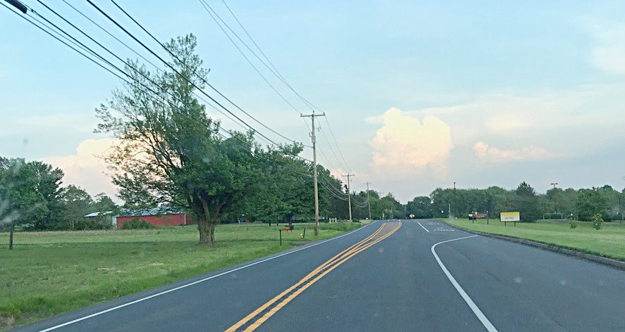
Due to the haze at the surface, even if it weren’t being obscured by the trees, you can’t tell whether there is any wall cloud or even a tornado dropping out of the base of these supercells.
Why Storms Form
Before science came along to explain meteorological phenomena, every culture had its myths about what causes storms, some quite fanciful. But in actuality, storms—indeed, all weather events—occur because Nature does not like an imbalance of energy.
Storms bubble up in areas where convective (heat) energy builds up in relatively small pockets. This creates an imbalance of heat and moisture compared to the surrounding airmass. Generally, the larger the imbalance, the stronger the storm. Lightning, rain and wind discharge these pockets, and the storm dies when a relative balance is achieved with the surrounding atmosphere.
How Storms Form and Die Out
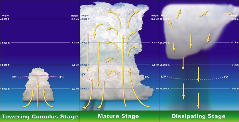
All thunderstorms, regardless of type, go through three stages:
- Developing, as it builds in size and strength
- Mature, when it’s at its strongest and most dangerous
- Dissipation, when the storm’s core energy is spent
Depending on atmospheric conditions, these three stages take an average of 30 minutes to cycle through. If you have good situational awareness, and are far enough away from the storm, you can actually watch thunderheads evolve through these stages.
The average thunderstorm has a 15-mile diameter, so it’s not difficult to stay out of their way unless there are a lot of them and they line up ahead of an advancing front into a squall line. That’s a nearly solid line of active storms. Then, your best bet is to seek a sheltered area to stay until they pass.
A thunderstorm officially turns severe when it produces:
- wind gusts of 50 knots (58 mph) or greater
- hail 3/4-inch in diameter or larger
- tornadoes
Often, for any number of reasons, it won’t be obvious that an approaching storm is severe. You may not be able to tell until viewing structural wind damage left afterward. That’s why, if you’re in an RV, you can’t afford to take chances. If a storm looks like it has any chance of being severe, just get out of its way until it passes.
It All Starts With Convection
Tornadoes, severe thunderstorms, and hail are all referred to as “convective events.” This means they depend on the energy from the sun (convection), heating up the earth’s surface during humid spells, to form.
When you’re on the road, one of the best ways to anticipate convective events is to monitor the Storm Prediction Center’s (SPC) Convective Outlook. This is a free website created by the National Weather Service (NWS), which anyone can access on a computer or mobile device.
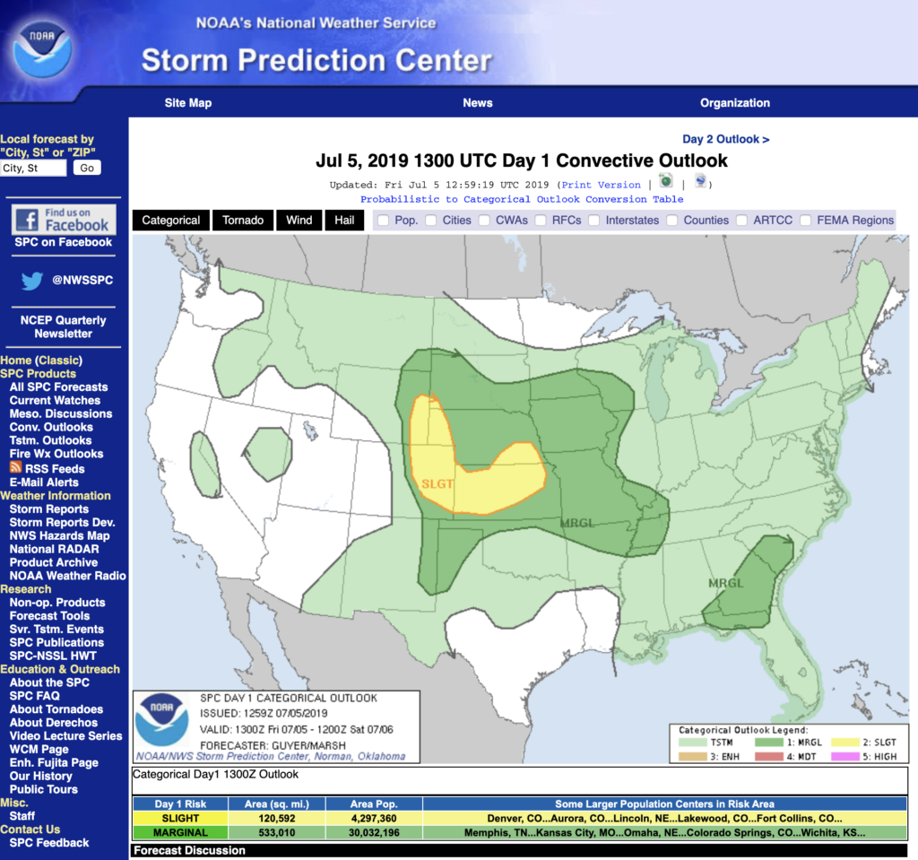
A few things to note about the SPC Convective Outlook:
- It is expressed in Day Outlooks. The current day is Day One. The next would be Day Two, and so on. They issue fairly firm outlooks for Days 1-3. After that, they will give a cursory, tentative outlook for Days 4-8.
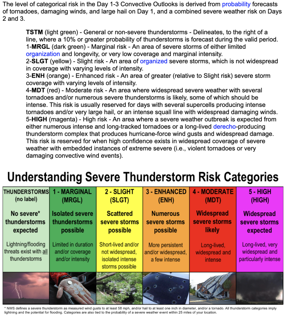
- They use this categorical scale to express intensity of probability for severe weather: General, Marginal, Slight, Enhanced, Moderate, High. For most folks, these all sound rather understated for what they mean. In reality, the SPC does not issue convective risk areas unless they believe there is seriously some potential for severe weather. So don’t be fooled by the mild labeling. Here is their own detailed explanation of what the categories actually denote regarding severe storm risk: (Note: blue links in graphic below are not clickable. The one term you may not be familiar with is derecho, a term for a line of intense, widespread, and fast-moving windstorms and sometimes thunderstorms that moves across a great distance, and is characterized by damaging winds.)
Yes, They Know.
For what it’s worth, the National Weather Service is fully aware that much of the nomenclature they use is confusing and difficult to use. Not just the Sever Risk Category naming as described above, but also the Watch, Warning and Advisory (WWA) system. So many folks still, after decades, do not clearly understand the difference between these three technical meteorology terms. And of course, there’s the problem of the sheer number of distinct hazard categories they cover. There are dozens of different weather and atmosphere conditions, and it can be overwhelming, even for forecasters. So the NWS has undertaken the huge Hazard Simplification Project. You can read more about what they’re doing here.
How Thunderstorms Build In Intensity
As hot, wet air rises into the atmosphere, on a day when storm risk is present, it collides with cold, dry air riding over the top of it. When the updrafts pushing it become fast enough, regular old cumulus clouds can become volatile, turning into cumulonimbus or “thunderheads.” These are the clouds that look like heads of cauliflower. Strong storms produce clouds with sharply defined edges, and they can be quite beautiful.
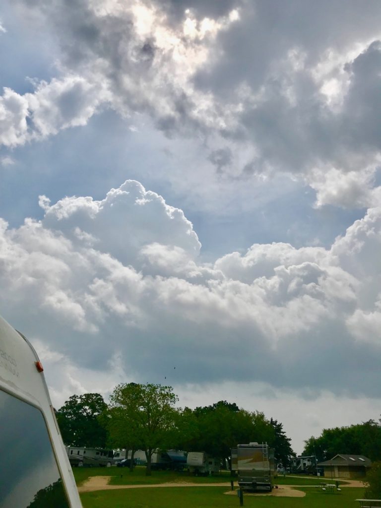
In this photo, you can see loose storm scud in the foreground and lower in the sky, while more sharply defined thunderheads are building in the background. You can see the strong sunshine, which was able to produce a lot of convection between the clouds. This eventually produced strong thunderstorms around 4 pm that day.
In this volatile environment, raindrops—having formed around microscopic specks of dirt, dust and other airborne debris—start crashing into each other, creating friction. When enough friction has built up, the pent-up energy discharges suddenly through a lightning bolt. This moves the air so quickly that a sudden vacuum is formed. This creates a thunderclap, much as your fingers displace air quickly when you snap your fingers (only, of course, in a much larger area).
When there is a great deal of convection caused by sunshine—either between storms or peeking through clouds—the energy created fuels these storms, and they can become violent. This is why most severe storms happen in the latter hours of afternoon and evening, after the sun has been beating down all day. For RVer purposes, you can rely most days on storms initiating between 4-7 pm local time.
You might think that the earlier the storms initiate, the earlier they will end, and in most cases, this is so. However, it depends on the size of the unstable airmass moving into your area, heat and moisture conditions at the surface and aloft, and how fast the low-pressure system creating the storms is moving. Generally, though, if storms initiate later in the evening, there is a good chance they may linger on into the night, which can be scary and dangerous, because you can no longer easily see the formation of funnel clouds and tornadoes.
This energy can cause updrafts that are so fast, they shoot up tends of thousands of feet. If they’re moving fast enough, they can break through what meteorologists refer to as “the cap.” This is a layer of dense, cold air that sits at the point where the troposphere—or surface layer of the atmosphere—hits the tropopause, or the buffering layer between the surface and the stratosphere, which is where outer space begins.
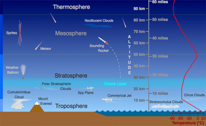
When a storm cell has risen high enough to hit the troposphere, the top of it flattens against the cap and spreads out to look like an anvil, as in the illustration above. It is now a fully developed, strong thunderstorm cloud. Storms that reach this stage are generally considered supercells.
More…
- RV Weather – Main Page
- RV Weather – Severe-Prone Areas of the U.S.
- RV Weather – Recognizing Severe Weather Conditions
- RV Weather – Weather Awareness and What To Do
- RV Weather – How Storms Turn Violent
- RV Weather – Types of Clouds to Watch For
- RV Weather – Hurricanes and Tropical Systems
- RV Weather – Snowstorms, Blizzards and Other Winter Stuff
- RV Weather – Smartphone Apps
- Current Severe Weather Alerts for Nomads – My Facebook Group
Recent Comments