
Inclement weather is a given if you spend enough time on the road. Everyone encounters less-than-ideal weather conditions now and then, and usually the most you have to do to avoid any unpleasant results is to pull over and wait it out.
But severe weather is a whole different story. Far from just inconveniencing you or maybe ruining a picnic or hike, severe weather has the potential to seriously hurt or even kill you.
The good news is that, as with other safety issues, you can mostly stay out of trouble by maintaining situational awareness around the potential for severe weather to develop at any given place or time. And it’s not at all difficult to learn what to look for to recognize severe weather conditions.
Get Severe Weather Training
One of the best and easiest ways to become familiar with the conditions that allow development of severe weather is to become a certified Skywarn Storm Spotter.
SkyWarn Spotter training is free and generally comes in two modules, introductory and advanced. You must take both to be certified. Most training sessions offer one module in the morning and another after lunch. Some even offer free lunch to trainees.
Once trained, you will be able to correctly identify signs of oncoming severe weather, and be authorized as a trained observer to report to the local National Weather Service office hazardous severe weather conditions such as hail, high winds, excessive rainfall and potential cloud rotation that may indicate a tornado.
The SkyWarn program is open to anyone aged 14 and up, and they actively seek new spotters. Spotters are the realtime eyes and ears of the NWS, and provide valuable “ground truth” to verify what forecasters may be seeing only on radar, and they are critical to issuing timely warnings for severe thunderstorms and tornadoes.
If you’re interested in weather, this is a very interesting and exciting thing to do. You learn how to use modern technologies to aid you in giving accurate and timely reports to local forecasters. Even if you’re not all that interested in weather other than staying safe on the road, it’s still a smart thing to do, and only takes a day of your time.
It used to be you had to attend Skywarn Spotter Training in person, but now many chapters are offering it online. Check at the Skywarn site for information on training offered in your area.
Other Ways To Learn Severe Weather Conditions
If you can’t or don’t want to attend Skywarn Spotter training, you can cruise around online looking for good information on how to identify impending severe weather conditions. Here are a few websites where you can find such information, along with tools for immediate needs in active weather situations. I’ve listed them in order of usefulness (my subjective opinion):
- Storm Prediction Center (SPC) – Storm-centric site. Daily Convective Outlooks, forecasts, thunderstorm and fire weather outlooks, mesoscale discussions, forecast tools and RSS feeds
- National Severe Storms Laboratory (NSSL) – Storm-centric site. Severe Weather 101 (comprehensive and really well done), weather research, tools, projects, people, education and news
- National Weather Service (NWS) – General weather site. National Doppler radar, forecasts, past weather history, safety, programs, education and news
- Severe Storms for Nomads – My Facebook group, created especially for road-dwellers in mobile homes and vehicles. We usually start the day with the SPC’s Day One Convective Outlook, then gather relevant information from other sources as needed. Updated as often as possible, especially during severe weather outbreaks.
You can also visit the National Weather Service Safety pages to learn specifically about
There are many factors that need to come together in the atmosphere to support the development of severe thunderstorms and tornadoes. If you can’t or don’t wish to get SkyWarn Spotter training, I’ve created the following “BART-RISC CHECKLIST” to make it easy to remember these factors:
BART-RISC CHECKLIST
BAROMETER - Is the air pressure dropping? That signals the approach of a low-pressure weather system, which is what produces inclement weather, including storms.
AMPLE SUNSHINE - One of the factors required to destabilize an airmass is convection or heat produced by the sun shining on the Earth's surface. If you have a lot of sunshine in the morning and early afternoon hours and the surrounding airmass is moist, there are two factors needed for the formation of storms.
RAIN OR HAIL - Heavy rain usually accompanies thunderstorms, and hail can often precede or follow a tornado.
TEMPERATURE - A warm or hot, moist airmass at the surface can support the development of storms if a layer of cold, relatively dry air rolls over the top of it from an incoming front. If you feel a sudden, significant drop in temperature outside, a storm is likely approaching quickly.
–
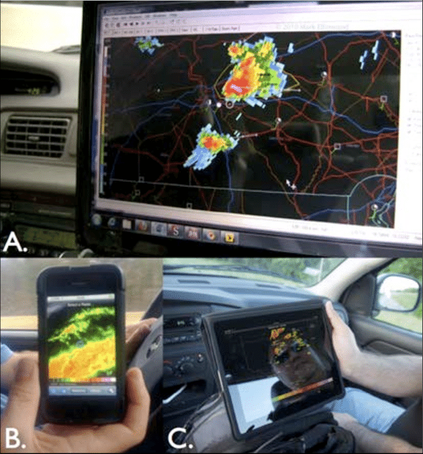
RADAR - Use your smartphone, tablet or laptop to access any of the numerous Doppler radar feeds available, either directly on websites or through apps. Watch for intense areas of rain, which usually show up as orange or red on radar. A cloud that's clearly forming a hook-like shape is usually a tornado forming. A hook that's got a magenta-colored core is an intense tornado on the ground. If a black spot appears in its center, that's the signature of a debris ball being lofted high in the air by the twister.
INTENSE, SUDDEN WIND SHIFT - If it has been relatively calm and a sudden gust of wind comes up, or if winds have primarily been blowing in one direction and that direction suddenly changes, there is almost certainly a significant thunderstorm headed your way. If it has been generally breezy or even windy, and there comes an abrupt calm, you may have a tornado bearing down on you.
SOUND - If you notice that a day which had previously offered birdsong, crickets chirping, and general nature sounds has suddenly become quiet, and any winds have died down to dead calm, you need to seek shelter immediately. These are telling clues that a violent thunderstorm or even a tornado is imminent. If you hear a dull roar in the distance, it may be heavy, dangerous hail, strong, straight-line winds, or even an approaching tornado.
CLOUDS - Use the Cloud Primer to familiarize yourself with the kinds of clouds to watch for in the development of severe storms. Generally, the lighter in tone a cloud appears, the less likely it is to contain rain. If low, white, puffy clouds turn into higher, grayer clouds, they are probably gathering moisture to dump, which is why they turn gray: sunlight can no longer pass through them because they're too thick with condensation. Extremely dark clouds that look midnight blue or even lighter are certainly storm clouds. If the clouds begin to rotate, you are probably looking at a dangerous supercell. If the supercell shows an aqua or teal-colored center, that's a hail core. If the whole sky turns a sickly yellowish-green, that's also a common characteristic of an imminent tornado.
Whenever you sense any of these factors may be present, it’s a good idea to start paying attention to the weather, because severe storms can and often do develop quickly. Make sure your weather radio is on, or that your weather app is set for audible notifications to alert you to imminent danger.
Most of all—regardless what you may or may not intellectually know—as a human being, you retain vestiges of the instincts that kept our prehistoric ancestors safe from dangerous weather. Pay attention to how you feel in what may be a situation that could include severe weather. Especially if you find yourself in a suddenly too-calm atmosphere and it gives you the creeps, listen to that and seek shelter. There’s a reason why eerie situations make our hair stand on end, which should serve as your own personal barometer for safety.
Learn All The Words
Another truly helpful tool for learning about weather is the National Oceanographic and Atmospheric Administration’s Comprehensive Glossary of Weather Terms. Be aware that this can get a little technical in parts, but you don’t have to be a storm spotter to use it. Though that’s who it is intended for, much of it is perfectly understandable by non-weather geeks. This reference gives you the correct words to use when discussing weather, and is helpful even outside of a storm spotting situation.
More:
- RV Weather – Main Page
- RV Weather – Severe-Prone Areas of the U.S.
- RV Weather – Weather Awareness and What To Do
- RV Weather – How Severe Weather Develops
- RV Weather – How Storms Turn Violent
- RV Weather – Types of Clouds to Watch For
- RV Weather – Hurricanes and Tropical Systems
- RV Weather – Snowstorms, Blizzards and Other Winter Stuff
- RV Weather – Smartphone Apps
- Current Severe Weather Alerts for Nomads - My Facebook Group
Recent Comments